|
|
|
Advertisements:
GeographyLocation
Europa occidental, isla en el mar de Irlanda, entre Irlanda y Gran Bretaña Geographic coordinates
54 15 N, 4 30 W
Map references
Europa
Area
Total 572 sq km
Land 572 sq km Water 0 sq km Area - comparative
Un poco más de tres veces el tamaño de Washington, DC Land boundaries
0 km
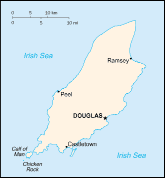
Coastline
160 km
Maritime claims
Territorial sea 12 nm
Exclusive fishing zone 12 nm Climate
Templado; veranos e inviernos templados; nublado alrededor de un tercio del tiempo Terrain
Colinas del Norte y sur, atravesada por el valle central Elevation extremes
Lowest point Irish Sea 0 m
Highest point Snaefell 621 m Natural resources
None
Land use
Arable land 10%
Permanent crops 0% Other 90% (permanent pastures, forests, mountain, and heathland) (2002) Irrigated land
0 sq km
Natural hazards
NA
Environment - current issues
Evacuación (domésticos e industriales); contaminación atmosférica transfronteriza Geography - note
Un pequeño islote, el becerro del hombre, se encuentra al suroeste y es un santuario de aves
Comentarios
Anade un comentario nuevo:: |
Advertisement
Login
Isla De Man [ Reino Unido ] (British Crown Dependency):
GPS puntos de Isla De Man [ Reino Unido ] (British Crown Dependency)
|
||||||||
 Parte del Reino noruego de las islas Hébridas hasta el siglo XIII, cuando fue cedido a Escocia, la isla se produjo bajo la corona británica en 1765. Preocupaciones actuales incluyen revivir el casi extinto idioma gaélico Manx. Isla de Man es una dependencia de la corona británica pero no es parte del Reino Unido o de la Unión Europea. Sin embargo, el Gobierno del Reino Unido sigue siendo constitucionalmente responsable de su defensa y representación internacional.