English   Română   Español   Français   Deutsch  

getamap.net

Africa

Oceania

Asia

America del Norte

Europa

America del Sur

La Antártida


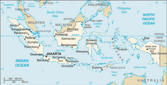
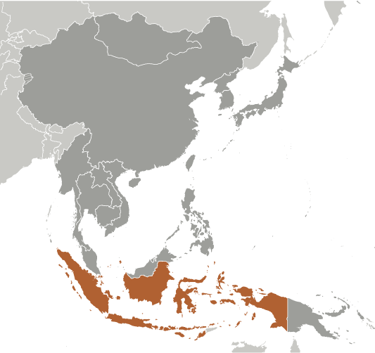
Daerah Tingkat I Kalimantan Timur

(Provinsi Kalimantan Timur) / East Kalimantan

1°30'0" N
116°30'0" E
~707m asl
19:12 (WITA - UTC/GMT+8)

Daerah Tingkat I Kalimantan Timur (Daerah Tingkat I Kalimantan Timur) es un/una de primer orden división administrativa (class A - Región Administrativa) en East Kalimantan (Kalimantan Timur), Indonesia (Asia) con un código de región de Asia/Pacific. Se encuentra a una altitud de 707 metros sobre el nivel del mar y su población es de 2,809,968.
Daerah Tingkat I Kalimantan Timur se conoce también como Aust-Kalimantan, Borneo Wschodnie, Daerah Tingkat I Kalimantan Timur, Dong Kalimantan, East Kalimantan, Itae-Kalimantan, Itä-Kalimantan, Kalimantan Est, Kalimantan Timur, Kalimantan Wetan, Kalimantan Wétan, Oost-Kalimantan, Ost-Kalimantan, Propinsi Kalimantan Timur, Provinsi Kalimantan Timur, dong jia li man dan, dongkarimantan zhou, ka li man tan tawan xxk, klymntn shrq, Øst-Kalimantan, Đông Kalimantan, كليمنتن شرق, กาลิมันตันตะวันออก, 東カリマンタン州, 東加里曼丹.

Sus coordenadas son 1°30'0" N y 116°30'0" E en formato DMS (grados, minutes, segundos) o 1.5 y 116.5 (en grados decimales). Su posición UTM es MG46 y su referencia Joint Operation Graphics es NA50-10.

La hora local actual es 19:12; el sol sale a las 08:55 y se pone a las 21:02 hora local (Asia/Makassar UTC/GMT+8). La zona horaria de Daerah Tingkat I Kalimantan Timur es UTC/GMT+8
En 2024 el horario de verano comienza el - y termina el -.

A De primer orden división administrativa es una división administrativa primaria del país, tales como un estado en los Estados Unidos.


Country
 Advertisements:


 Advertisements:


El tiempo Daerah Tingkat I Kalimantan Timur (Nubosidad, Temperatura, Velocidad del viento y Precipitación mm probab.)

Fri


Apr 19
Clound 60-20-10-70 Mist Lightning
~17 l/m2 63%
 
20 °C min
28 °C max
5 km/h
Thu Jan 1

Sat


Apr 20
Clound 40-20-0-80 Lightning
~13 l/m2 46%
 
19 °C min
30 °C max
6 km/h
Thu Jan 1

Sun


Apr 21
Clound 10-20-0-100
~0.3 l/m2 15%
 
20 °C min
32 °C max
8 km/h
Thu Jan 1

Mon


Apr 22
Clound 10-20-10-100 Lightning
~2 l/m2 35%
 
19 °C min
31 °C max
7 km/h
Thu Jan 1

Tue


Apr 23
Clound 30-40-60-100 Lightning
~17 l/m2 89%
 
19 °C min
28 °C max
7 km/h
Thu Jan 1

Wed


Apr 24
Clound 40-20-20-100 Lightning
~26 l/m2 78%
 
19 °C min
27 °C max
5 km/h
Thu Jan 1

El tiempo Graph

Provinsi Kalimantan Timur (East Kalimantan) 7 días de previsión
 

Mapa y Fotos Daerah Tingkat I Kalimantan Timur


Comentarios

--- No hay comentarios ---


Anade un comentario nuevo::


Tienes que ingresar para anadir un comentario!


Advertisement


Login


Register

¿Olvidó contraseña?

Indonesia (Jakarta):

GPS puntos de Indonesia (Jakarta)

square Tengkokbiawa Riau Islands

square Soerabaja West Java

square Desa Ngerangan Central Java

square Sungai Merbau Provinsi Riau

square Danau Tondano Sulawesi Utara

square Njaroemkop Indonesia (general)

square Kabupaten Gianjar Indonesia (general)

square Pulau Umpang Bangka-belitung


viewweather.com sv.ViewWeather.com
fr.ViewWeather.com
da.ViewWeather.com
de.ViewWeather.com
es.ViewWeather.com
www.carpati.org
www.searchromania.net
Deblocari usi
es.getamap.org
fr.getamap.org
de.getamap.org
nl.getamap.org
da.getamap.org
www.getamap.org
Enlaces
Condiciones de uso
Política de privacidad

# 0.0640 sec 

contact AT getamap.net

© 2006 - 2024  https://es.getamap.net/