English   Română   Español   Français   Deutsch  

getamap.net

Africa

Oceania

Asia

America del Norte

Europa

America del Sur

La Antártida


Hururu Creek

(Zion Hill) / Upper Demerara-Berbice Region

5°46'0" N
58°22'60" W
~75m asl
19:01 (GYT - UTC/GMT--4)

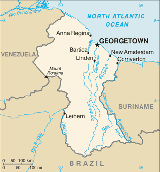
Hururu Creek (Hururu Creek) es un/una corriente (class H - Hidrográfica) en Upper Demerara-Berbice Region (Upper Demerara-Berbice), Guyana (South America) con un código de región de Americas/Western Europe. Se encuentra a una altitud de 75 metros sobre el nivel del mar.

Sus coordenadas son 5°46'0" N y 58°22'60" W en formato DMS (grados, minutes, segundos) o 5.76667 y -58.3833 (en grados decimales). Su posición UTM es UG43 y su referencia Joint Operation Graphics es NB21-10.

La hora local actual es 19:01; el sol sale a las 08:54 y se pone a las 21:01 hora local (America/Guyana UTC/GMT-4). La zona horaria de Hururu Creek es UTC/GMT-4
En 2024 el horario de verano comienza el - y termina el -.

A Corriente es un cuerpo de agua corriente en movimiento a un nivel inferior en un canal en tierra.


Country
 Advertisements:


 Advertisements:


El tiempo Hururu Creek (Nubosidad, Temperatura, Velocidad del viento y Precipitación mm probab.)

Thu


Apr 25
Clound 0-30-0-100
 
24 °C min
34 °C max
14 km/h
Thu Jan 1

Fri


Apr 26
Clound 0-50-0-70 Mist Lightning
 
21 °C min
34 °C max
14 km/h
Thu Jan 1

Sat


Apr 27
Clound 10-60-10-40 Mist Lightning
~0.4 l/m2 42%
 
22 °C min
32 °C max
10 km/h
Thu Jan 1

Sun


Apr 28
Clound 20-60-10-40 Lightning
~5 l/m2 54%
 
22 °C min
33 °C max
11 km/h
Thu Jan 1

Mon


Apr 29
Clound 30-50-20-40 Lightning
~10 l/m2 50%
 
23 °C min
32 °C max
11 km/h
Thu Jan 1

Tue


Apr 30
Clound 40-50-30-70 Mist Lightning
~19 l/m2 63%
 
23 °C min
32 °C max
11 km/h
Thu Jan 1

El tiempo Graph

Zion Hill (Upper Demerara-Berbice Region) 7 días de previsión
 

Mapa y Fotos Hururu Creek


Comentarios

--- No hay comentarios ---


Anade un comentario nuevo::


Tienes que ingresar para anadir un comentario!


Login


Register

¿Olvidó contraseña?

Guyana (Georgetown):

Advertisement


GPS puntos cerca de Hururu Creek

GPS puntos de Guyana (Georgetown)

square Strathaven Mahaica-berbice Region

square Werk En Rust Demerara-mahaica Region

square Kubanawau River Upper Takutu-upper Essequibo Region

square Akar Cuyuni-mazaruni Region

square Ikuraka Creek Pomeroon-supenaam Region

square Little Lanaballi Creek Essequibo Islands-west Demerara Region

square De Hoop Mahaica-berbice Region

square River Kanow Cuyuni-mazaruni Region


viewweather.com sv.ViewWeather.com
fr.ViewWeather.com
da.ViewWeather.com
de.ViewWeather.com
es.ViewWeather.com
www.carpati.org
www.searchromania.net
Deblocari usi
es.getamap.org
fr.getamap.org
de.getamap.org
nl.getamap.org
da.getamap.org
www.getamap.org
Enlaces
Condiciones de uso
Política de privacidad

# 0.0679 sec 

contact AT getamap.net

© 2006 - 2024  https://es.getamap.net/