English   Română   Español   Français   Deutsch  

getamap.net

Africa

Oceania

Asia

America del Norte

Europa

America del Sur

La Antártida


Mottesundet

(Motte Sound) / Bouvetoya (general)

54°27'12" S
3°19'10" E
~0m asl
( - UTC/GMT+)

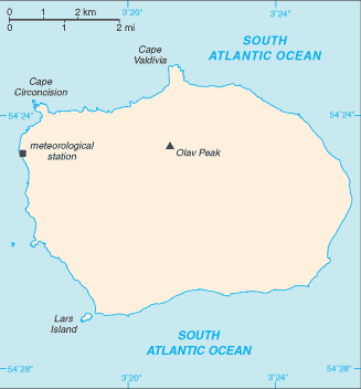
Mottesundet (Mottesundet) es un/una canal (class H - Hidrográfica) en Bouvetoya (general) (Bouvet Island (general)), Isla Bouvet [ Noruega ] (Antarctica) con un código de región de Americas/Western Europe...
Mottesundet se conoce también como Motte Sound, Mottesundet.

Sus coordenadas son 54°27'12" S y 3°19'10" E en formato DMS (grados, minutes, segundos) o -54.4533 y 3.31944 (en grados decimales). Su posición UTM es EV26 y su referencia Joint Operation Graphics es SN31-08.

La hora local actual es ; el sol sale a las 08:55 y se pone a las 21:02 hora local ( UTC/GMT+). La zona horaria de Mottesundet es UTC/GMT+
En 2024 el horario de verano comienza el - y termina el -.

A Canal es la parte más profunda de un arroyo, la bahía, laguna, o estrecho, a través del cual fluye la corriente principal.


Country
 Advertisements:


 Advertisements:


El tiempo Mottesundet (Nubosidad, Temperatura, Velocidad del viento y Precipitación mm probab.)

Thu


Apr 18
Clound 20-100-50-0 Mist
~0.3 l/m2 42%
 
0 °C min
1 °C max
40 km/h
Thu Jan 1

Fri


Apr 19
Clound 10-80-50-40 Mist
~0.4 l/m2 57%
 
0 °C min
2 °C max
36 km/h
Thu Jan 1

Sat


Apr 20
Clound 0-90-70-60 Mist
~3 l/m2 67%
 
0 °C min
3 °C max
62 km/h
Thu Jan 1

Sun


Apr 21
Clound 0-80-30-40 Mist
~0.4 l/m2 52%
 
0 °C min
3 °C max
55 km/h
Thu Jan 1

Mon


Apr 22
Clound 0-60-90-100 Mist
~3 l/m2 65%
 
2 °C min
3 °C max
46 km/h
Thu Jan 1

Tue


Apr 23
Clound 0-80-70-80 Mist
~4 l/m2 71%
 
2 °C min
4 °C max
55 km/h
Thu Jan 1

El tiempo Graph

Motte Sound (Bouvetoya (general)) 7 días de previsión
 

Mapa y Fotos Mottesundet


Comentarios

--- No hay comentarios ---


Anade un comentario nuevo::


Tienes que ingresar para anadir un comentario!


Login


Register

¿Olvidó contraseña?

Isla Bouvet [ Noruega ] (Norway):

Advertisement


GPS puntos cerca de Mottesundet

square Catoodden (0.5km)

square Cato Point (0.5km)

square Seal Point (0.5km)

square Lars Island (0.5km)

square Lars Islet (0.5km)

square Larsoya (0.5km)

square Benn Skerries (0.5km)

square Bennskjaer (0.5km)

square Bennskjaeret (0.5km)

square Rustad Knoll (0.5km)

square Rustadkollen (0.5km)

square Bolle Bay (0.5km)

square Bollevika (0.5km)

square Lykke Peak (1 km)

square Lykkes Topp (1 km)

square Lykketoppen (1 km)

square Rauberhohle (2 km)


GPS puntos de Isla Bouvet [ Noruega ] (Norway)

square Litle-kari Bouvetoya (general)

square Morgenstierne Coast Bouvetoya (general)

square Lindsay Reef Bouvetoya (general)

square Benn Skerries Bouvetoya (general)

square Olav Peak Bouvetoya (general)

square Cape Fie Bouvetoya (general)

square Wilhelm Ii Plateau Bouvetoya (general)

square Spiess Rocks Bouvetoya (general)


viewweather.com sv.ViewWeather.com
fr.ViewWeather.com
da.ViewWeather.com
de.ViewWeather.com
es.ViewWeather.com
www.carpati.org
www.searchromania.net
Deblocari usi
es.getamap.org
fr.getamap.org
de.getamap.org
nl.getamap.org
da.getamap.org
www.getamap.org
Enlaces
Condiciones de uso
Política de privacidad

# 0.0585 sec 

contact AT getamap.net

© 2006 - 2024  https://es.getamap.net/